
SERIES II
Launched in 2005, Google Earth was the first interactive composite map of the world. Where is the first place you searched? Your house of course.
Did the search result in the correct location or did the pin drop down the street? How grainy was the image? Did it paint clear picture of your neighborhood?
FAST FORWARDING TECHNOLOGY »
Fast forward to 2007, when Google Street View premiered its interactive panoramas from a position along the street (in select areas of course). One step closer to virtually taking you there.
Now fast forward to 2019 when Google Earth on the web (accessible on Chrome, but not so compatible with Safari) announced their “creation tools” or Google’s Tour Builder, you can produce product visits highlighting and narrating around the amenities, sites or building in the region.
Watch this short video to see how a classroom, a conservationist and a family are using the creation tools to share stories about a place that matters to them.
MASTER SHOWCASING YOUR COMMUNITY »
With minimal effort and just a little time, you can create an amazing tour to showcase your community’s amenities in the virtual world using Google Earth Pro and Google Earth’s creation tools.
Google Earth’s platforms: Google Earth Pro and Google Earth on the web remain one of the top, FREE mapping platforms out there.
Is it a Geographical information Systems (GIS) platform? No, but you can upload GIS data to Google Earth Pro by creating your own or downloading a keyhole markup language file? More commonly known as a kml file, which simply refers to a file format that is used to display geographic data in Google Earth.
Make sure to check out these free and useful kml downloads for your community:
- USGS Topographic Layer
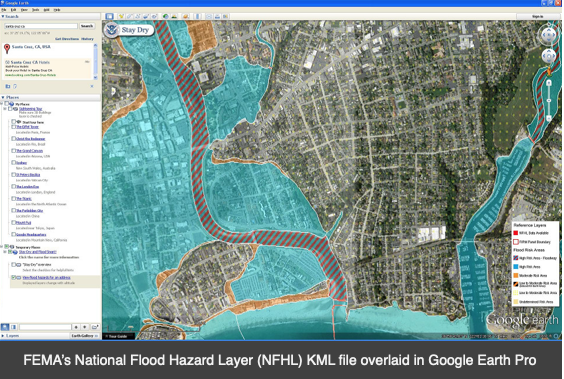
- FEMA NFHL – Flood Hazard Zones
- U.S. Census Geographies offers a wide array kml files, mostly around geographic boundaries – counties, congressional districts, metropolitan and micropolitan statistical areas.
- U.S. Fish and Wildlife Services National Wetland Inventory – Wetlands Maps
- Or you can create your own kml or overlays in Google Earth Pro – a step by step guide is available here. Drawing your outlines and shapes can be done quickly and easily and, but just remember – use the APWA color guide when outlining current and proposed utility infrastructure.
TAKE IT TO UP A NOTCH »
Once you have mastered the Google map/tour challenges, it is time to take it up a notch. You all have photos, engineering drawings of your site/building or at least screenshot of your industrial properties using some type of online mapping feature. You may even have advanced to drone video level.
For a minimal investment you can incorporate 360-degree photos (or videos) taken with a 360 camera or a drone into your marketing materials. Photos can be uploaded to an online platform – for free or at a minimal cost.
- Enjoy this guide to the best 360-degree cameras in 2020.
- Popular 360 Virtual Tour platform include: Kuula, 360cities or RoundMe
These are just a few easy, inexpensive options that can make a huge impact on your marketing materials and virtual site visits.
VIRTUAL MASTERCLASS COMING SOON »
Be on the lookout for an upcoming “virtual masterclass” offered by VisionFirst where we virtually walk you through the tools we discussed, answer questions and give you a list a free downloads that are guaranteed to enhance your marketing efforts.
If you can’t wait for the masterclass or prefer a one-on-one/group training, contact us.
We are here to help. Normally, I’d invite you to come see us in Florida and Mississippi (Tallahassee, Orlando and Jackson, for future reference). For now, we can help make it easier for you. VisionFirst offers a suite of services including our new program » re:Vision – a community performance program.

We developed this program as a result of one of the most common questions we get – “how do our properties, marketing materials, website, presentations and RFIs) compared to others?” We encourage you to contact us to discover our unique and practical approach to enhancing your marketing efforts and community competitive advantages.
Go and create something awesome!
Greg Word, Senior Consultant
Recent Comments